
UNIT 1: PHYSICAL GEOGRAPHY
Basics: Spatial Understanding
Geography is about spatial understanding, which requires an accurate grid system to determine absolute and relative location. Absolute location is the exact x- and y- coordinate on the Earth. Relative location is the location of something relative to other entities. For example, when you use your GPS in your smart phone or car, say Google Maps, you put in an absolute location. But as you start driving, the device tells you to turn right or left relative to objects on the ground: "Turn left on exit 202"is relative to the other exit points. If you give directions to your house, you often use relative locations to help them understand how to get to your house.
 Great and Small Circles
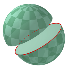
Much of Earth's grid system is based on the location of the North Pole, South Pole, and Equator. The poles are an imaginary line running from the axis of Earth's rotation. The plane of the equator is an imaginary horizontal line that cuts the earth into two equal halves. This brings up the topic of great and small circles. A great circle is any circle that divides the earth into a circumference of two equal halves. It's also the largest circle that can be drawn on a sphere. The line connecting any points along a great circle is also the shortest distance between those two points. Examples of great circles include the Equator, all lines of longitude, the line that divides the earth into day and night called the circle of illumination , and the plane of ecliptic, which divides the earth into equal halves along the equator. Small circles are circles that cut the earth, but not into equal halves. Examples of small circles include all lines of latitude except the equator, the Tropical of Cancer, Tropic of Capricorn, the Arctic Circle, and Antarctic Circle.
Latitude and Longitude
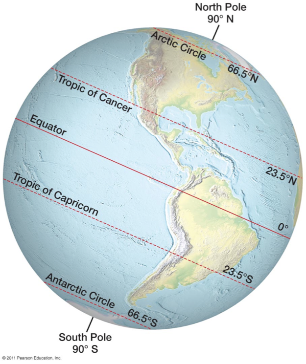
Many think that latitude is a line connecting points on the earth and it's not. Latitude is actually an angular measurement north or south of the equator. So 30 degrees north means a point that is 30 degrees north of the equator. Latitude is also expressed in degrees, minutes, and seconds; 360 degrees in a circle, 60 minutes ( ' ) in a degree, and 60 seconds ( " ) in a minute. When you use Google Earth, the coordinate locations are in this degrees/minutes/seconds format. Latitude varies from 0 degrees (equator) to 90 degrees north and south (the poles).
A line connecting all points of the same latitude is called a parallel, because the lines run parallel to each other. The only parallel that is also a great circle is the equator. All other parallels are small circles. The
following are the most important parallel lines:
-
Equator, 0 degrees
-
Tropic of Cancer, 23.5 degrees N
-
Tropic of Capricorn, 23.5 degrees S
-
Arctic Circle, 66.5 degrees N
-
Antarctic Circle, 66.5 degrees S
-
North Pole, 90 degrees N (infinitely small circle)
-
South Pole, 90 degrees S (infinitely small circle)
Latitude is also sometimes described as zones of latitude. Some of these zones of latitude include:
-
Low latitude - generally between the equator and 30 degrees N
-
Midlatitude - between 30 degrees and 60 degrees N and S
-
High latitude - latitudes greater than about 60 degrees N and S
-
Equatorial - within a few degrees of the equator
-
Tropical - within the tropics (between 23.5 degrees N and 23.5 degrees S
-
Subtropical - slightly pole-ward of the tropics, generally around 25-30 degrees N and S
-
Polar - within a few degrees of the North or South Pole
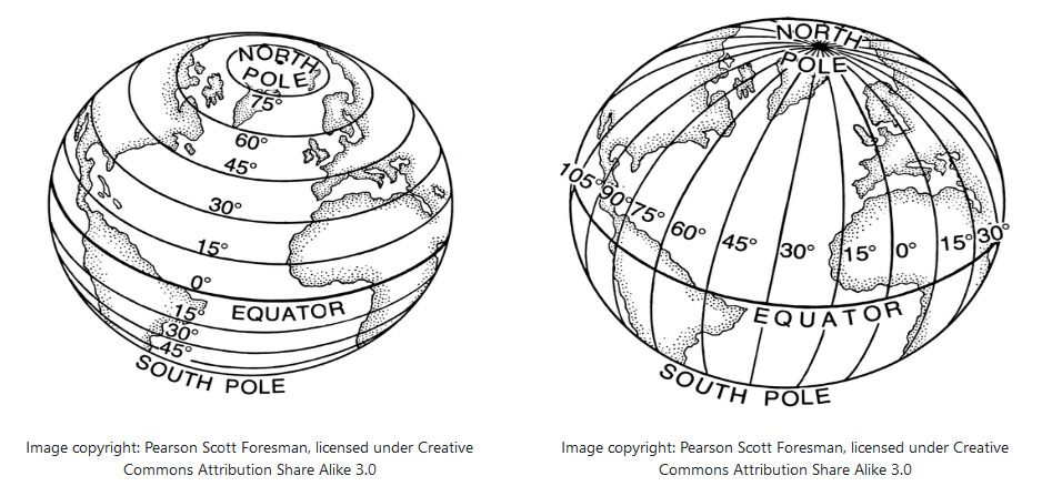
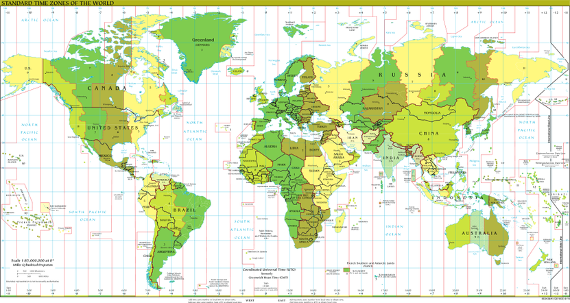
Longitude is the angular measurement east and west of the Prime Meridian (image on the right). Like latitude, longitude is measured in degrees, minutes, and seconds. Lines connecting equal points of longitude are called meridians. But unlike parallels, meridians do not run parallel to each other. Rather they are farthest apart from each other at the equator and merge toward each other toward the poles. The problem with longitude is that there isn't a natural baseline like the equator is for latitude. For over a hundred years, nations used their own "prime meridian" which proved problematic for trade. But in 1883 an international conference in Washington D.C. was held to determine a global prime meridian. After weeks of debate, the Royal Observatory at Greenwich, England was determined as the Greenwich Meridian or also called the prime meridian for the world. So today, longitude starts at the Prime Meridian and measures east and west of that line.
At 180 degrees of the Prime Meridian in the Pacific Ocean is the International Date Line. The line determines where the new day begins in the world. Now because of this, the International Date Line is not actually a straight line, rather it follows national borders so that a country isn't divided into two separate days (and we think hour time zones are a pain). If you look at the map above, the International Date Line is to the right in a dark, black line. Note how it is drawn to make sure nations are not divided by the International Date Line.
Contour and Gradients
A contour line on a map is a line that joins points of equal elevation.
Watch the video below to understand how this concept works on a natural landscape.
Gradient is a measurement of the steepness of the land or simply slope.
Formula: